Formation

Hurricanes are heat engines, driven by two different thermal gradients. At birth, hurricanes start out as a small group of thunderstorms, formed from convective air motions due to the vertical difference in temperature between warm ocean water and cooler air above. Later, when the storm has matured some, it develops a warm-cored structure, which means that the air temperature increases as one moves A simplified diagram showing how surfaces of constant pressure are bent such that air pressure is lowered near the surface and raised in the upper atmosphere in a warm-core cyclone.
Image courtesy: Engle - Hurricane Science Center towards the center of the storm (horizontal gradient). The temperature difference between the core and the outskirts of the storm is due to the release of latent heat from the intense thunderstorms near the center. Both of these thermal gradients act to decrease the surface air pressure at the center of the storm, increasing the pressure gradient force, and thus, the wind speed.
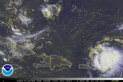
A few pre-existing conditions must be present to support tropical storm formation. The sea surface temperature generally has to be greater than 26C to induce barotropic instability, and the difference in direction and speed (shear) between upper and lower level winds must be small. Wind shear disrupts the vertical air motions within thunderstorms and pushes them away from the center of a
tropical cyclone, which in turn distrupts the
entire storm's circulation. Shear can also Tropical Storm Chris in 2006 gets
introduce mid-level dry air into the circulation, sheared by upper-level winds from
which induces evaporation within the moist the north, pushing thunderstorms
thunderstorms, cooling the air and causing it away from the center of circulation.
to sink. This increase in downdrafts can Image Courtesy: NOAA
destroy thunderstorm production and greatly
inhibit the storm's ability to intensify. Thus, low wind shear is one of the most important criteria for tropical storm development, as even with very warm water, it can weaken a storm or even prevent its formation. These two main conditions only exist in the tropical oceans, which is where tropical cyclones are found.
There also has to be an existing disturbance in the atmosphere causing convergence and an area of low pressure, from which a feedback process can be initiated. As air flows at the surface towards the low pressure area, it picks up moisture from the ocean, making it less dense and more buoyant. This, combined with the warmth from the ocean, causes the air to rise and expand near the center of low pressure. This results in condensation of water vapor into clouds, releasing latent heat which intensifies the convective cell. This lowers the surface pressure further, which in turn draws in more air, which releases more latent heat, and so on. This feedback process is called Convective Instability of the Second Kind, and is the primary mechanism by which hurricanes intensify.
The Coriolis Force
Simply having an area of low pressure is not enough, however. Another factor comes into play, called the Coriolis force (or Coriolis effect). This is an apparent acceleration on objects moving parallel to a rotating surface, such as the Earth. It is difficult to even consider it as a "real" force, since it only appears in the rotational frame of reference, but not in the intertial frame of reference, so it is sometimes referred to as the Coriolis "effect." The Coriolis force on a particle is expressed as:
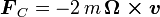
where m is the mass of the particle, is
the velocity vector of the particle, and Ω
is the
angular velocity vector, which is directed along the axis
of rotation of the rotating frame of reference. This force is
proportional to the sine of the angle between the particle's velocity
and the axis of the Earth's rotation, which means that the Coriolis
force is zero at the equator. Poleward of the equator, because of the
vector cross-product, the Coriolis force accelerates objects to the
right of where they travel in the northern hemisphere, and to the left
of where they travel in the southern hemisphere. This force reaches a
maximum at the poles.
is
the velocity vector of the particle, and Ω
is the
angular velocity vector, which is directed along the axis
of rotation of the rotating frame of reference. This force is
proportional to the sine of the angle between the particle's velocity
and the axis of the Earth's rotation, which means that the Coriolis
force is zero at the equator. Poleward of the equator, because of the
vector cross-product, the Coriolis force accelerates objects to the
right of where they travel in the northern hemisphere, and to the left
of where they travel in the southern hemisphere. This force reaches a
maximum at the poles.
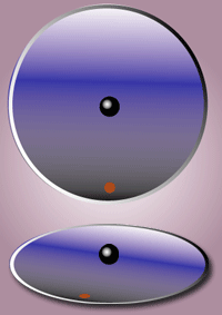
The Coriolis force is important because without it it would be very hard to get concentrated, isolated
areas of low pressure that can feedback on themselves Image Courtesy: Wiki
in the tropics. Because of this, tropical cyclones rarely
develop near the equator, and in general stay poleward of 5 degrees latitude. When a tropical disturbance is developing, the Coriolis force causes the air to spiral counterclockwise towards the center of low pressure. This allows the air to converge into spiral bands, enhancing convection and organization. The larger distance needed to travel to the center of a spinning storm also increases the amount of moisture picked up by the air before reaching it.
Once a tropical disturbance starts its feedback process, and all the required atmospheric conditions are met, it will continue intensifying until it is stopped by natural limits to the heat engine, such as the ocean surface temperature. The first stage of tropical cyclone development is that of a tropical depression, where a closed circulation about an area of low pressure develops, with organized thunderstorm activity near the center. A tropical depression can then intensify into a tropical storm if it attains sustained winds of greater than 39mph. If the storm reaches sustained winds of greater than 74mph, it is then a hurricane.
Hurricanes are heat engines, driven by two different thermal gradients. At birth, hurricanes start out as a small group of thunderstorms, formed from convective air motions due to the vertical difference in temperature between warm ocean water and cooler air above. Later, when the storm has matured some, it develops a warm-cored structure, which means that the air temperature increases as one moves A simplified diagram showing how surfaces of constant pressure are bent such that air pressure is lowered near the surface and raised in the upper atmosphere in a warm-core cyclone.
Image courtesy: Engle - Hurricane Science Center towards the center of the storm (horizontal gradient). The temperature difference between the core and the outskirts of the storm is due to the release of latent heat from the intense thunderstorms near the center. Both of these thermal gradients act to decrease the surface air pressure at the center of the storm, increasing the pressure gradient force, and thus, the wind speed.
A few pre-existing conditions must be present to support tropical storm formation. The sea surface temperature generally has to be greater than 26C to induce barotropic instability, and the difference in direction and speed (shear) between upper and lower level winds must be small. Wind shear disrupts the vertical air motions within thunderstorms and pushes them away from the center of a
tropical cyclone, which in turn distrupts the
entire storm's circulation. Shear can also Tropical Storm Chris in 2006 gets
introduce mid-level dry air into the circulation, sheared by upper-level winds from
which induces evaporation within the moist the north, pushing thunderstorms
thunderstorms, cooling the air and causing it away from the center of circulation.
to sink. This increase in downdrafts can Image Courtesy: NOAA
destroy thunderstorm production and greatly
inhibit the storm's ability to intensify. Thus, low wind shear is one of the most important criteria for tropical storm development, as even with very warm water, it can weaken a storm or even prevent its formation. These two main conditions only exist in the tropical oceans, which is where tropical cyclones are found.
There also has to be an existing disturbance in the atmosphere causing convergence and an area of low pressure, from which a feedback process can be initiated. As air flows at the surface towards the low pressure area, it picks up moisture from the ocean, making it less dense and more buoyant. This, combined with the warmth from the ocean, causes the air to rise and expand near the center of low pressure. This results in condensation of water vapor into clouds, releasing latent heat which intensifies the convective cell. This lowers the surface pressure further, which in turn draws in more air, which releases more latent heat, and so on. This feedback process is called Convective Instability of the Second Kind, and is the primary mechanism by which hurricanes intensify.
The Coriolis Force
Simply having an area of low pressure is not enough, however. Another factor comes into play, called the Coriolis force (or Coriolis effect). This is an apparent acceleration on objects moving parallel to a rotating surface, such as the Earth. It is difficult to even consider it as a "real" force, since it only appears in the rotational frame of reference, but not in the intertial frame of reference, so it is sometimes referred to as the Coriolis "effect." The Coriolis force on a particle is expressed as:
where m is the mass of the particle,
is
the velocity vector of the particle, and Ω
is the
angular velocity vector, which is directed along the axis
of rotation of the rotating frame of reference. This force is
proportional to the sine of the angle between the particle's velocity
and the axis of the Earth's rotation, which means that the Coriolis
force is zero at the equator. Poleward of the equator, because of the
vector cross-product, the Coriolis force accelerates objects to the
right of where they travel in the northern hemisphere, and to the left
of where they travel in the southern hemisphere. This force reaches a
maximum at the poles.The Coriolis force is important because without it it would be very hard to get concentrated, isolated
areas of low pressure that can feedback on themselves Image Courtesy: Wiki
in the tropics. Because of this, tropical cyclones rarely
develop near the equator, and in general stay poleward of 5 degrees latitude. When a tropical disturbance is developing, the Coriolis force causes the air to spiral counterclockwise towards the center of low pressure. This allows the air to converge into spiral bands, enhancing convection and organization. The larger distance needed to travel to the center of a spinning storm also increases the amount of moisture picked up by the air before reaching it.
Once a tropical disturbance starts its feedback process, and all the required atmospheric conditions are met, it will continue intensifying until it is stopped by natural limits to the heat engine, such as the ocean surface temperature. The first stage of tropical cyclone development is that of a tropical depression, where a closed circulation about an area of low pressure develops, with organized thunderstorm activity near the center. A tropical depression can then intensify into a tropical storm if it attains sustained winds of greater than 39mph. If the storm reaches sustained winds of greater than 74mph, it is then a hurricane.