Development
and Maturation
As a hurricane develops and intensifies, there are several characteristics which come and go as the dynamic behavior changes. A mature hurricane's general structure consists of an ideally symmetric region of convection, with a clear area at the center called the "eye," which is probably a hurricane's most defining characteristic. The convection organizes into spiral bands that converge inward toward an intense ring of convection encircling the eye called the eyewall. This is where the region of maximum vertical velocity of air is located, and thus is where the maximum tangential wind speed at the surface occurs. The eyewall is the innermost portion of a central core of intense convection called the central dense overcast (CDO). This general structure is naturally the most prominent and symmetrically defined in more mature cyclones, and its development is a process that must be undergone by every developing hurricane.
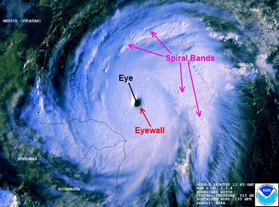
The typical structure of a mature hurricane, illustrated using Hurricane Mitch in 1998.
Image Courtesy: NOAA - Operational Significant Event Imagery
Hurricanes in their developing phase generally start out small, with only a small central core of convection that doesn't yet have a symmetrical structure. It usually has what is called a "banded" structure, with the outer spiral bands feeding into a tightly-wraped center. As the convective process feeds back on itself, continuing to intensify the hurricane, the storm can eventually develop an eye.
The Eye
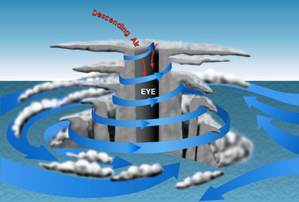
The eye of a hurricane is one of its most defining and beautiful features, but not every hurricane has one. An eye is a region of sinking air and relatively few clouds at the center of a tropical cyclone. It develops primarily from the warming of the upper atmosphere at the center of the storm by latent heat release from intense convection. This warming causes the air in the upper levels
of the troposphere to Image Courtesy: Diana Engle
expand, increasing the air pressure at that
level. This induces sinking air motion right at the center of the storm, which can eventually clear the clouds out all the way to the surface, creating the clear eye that we associate with strong hurricanes. As that last statement implies, only strong, major hurricanes (category 3 or higher) usually have clear, well-defined eyes. Most of the time, category 1 and 2 hurricanes don't yet have the necessary amount of energy release to generate and support this kind of inner core structure.
Most of the major evolutions that a major hurricane goes through involve its eye and inner core. By far the most traumatic of these is the eyewall replacement cycle (EWRC). As a hurricane intensifies, its eye usually contracts, eventually reaching a point where the inner spiral bands form another solid ring of convection around it called the concentric secondary eyewall. After this happens, the inner eyewall starts to weaken, and eventually dissipates, allowing the outer eyewall to contract and take over. This process usually takes between 24 and 48 hours to fully complete, and the hurricane generally weakens during this period of disorganized inner core dynamics. After the cycle completes though, the hurricane will often restrengthen, sometimes to a higher intensity than before. EWRCs generally take place only in major hurricanes, which typically undergo at least one such cycle during their lifetime. The image below shows Typhoon Amber in the western Pacific exhibiting concentric eyewalls during an eyewall replacement cycle.
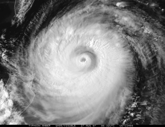
Image Courtesy: Cooperative Institute for Meteorological Satellite Studies
Although hurricanes are very powerful, self-sustaining storms, they all eventually weaken and dissipate. The most common causes of dissipation are wind shear disrupting the convective organization of the storm, or the storm moving over cooler water which can't support deep convection. A tropical cyclone making landfall will begin to weaken nearly instantly, since the heat resovoir driving the heat engine is suddenly taken away.Many storms don't actually fully dissipate, but recurve into the mid-latitudes where they undergo extratropical transition into a baroclinic system.
~~~~~~~~~~~~~~~~~~~~~~~~~~~~~~~~~~~~~~~~~~~~~~~~~~~~~~~~~
This video shows the life cycle of Hurricane Rita as she tracked across the Gulf of Mexico in 2005, eventually making landfall at Port Arthur in western Louisiana. Notice the eyewall replacement cycle that Rita underwent in the middle of the gulf, which she did not have time to fully complete before she ran into Louisiana.
As a hurricane develops and intensifies, there are several characteristics which come and go as the dynamic behavior changes. A mature hurricane's general structure consists of an ideally symmetric region of convection, with a clear area at the center called the "eye," which is probably a hurricane's most defining characteristic. The convection organizes into spiral bands that converge inward toward an intense ring of convection encircling the eye called the eyewall. This is where the region of maximum vertical velocity of air is located, and thus is where the maximum tangential wind speed at the surface occurs. The eyewall is the innermost portion of a central core of intense convection called the central dense overcast (CDO). This general structure is naturally the most prominent and symmetrically defined in more mature cyclones, and its development is a process that must be undergone by every developing hurricane.
The typical structure of a mature hurricane, illustrated using Hurricane Mitch in 1998.
Image Courtesy: NOAA - Operational Significant Event Imagery
Hurricanes in their developing phase generally start out small, with only a small central core of convection that doesn't yet have a symmetrical structure. It usually has what is called a "banded" structure, with the outer spiral bands feeding into a tightly-wraped center. As the convective process feeds back on itself, continuing to intensify the hurricane, the storm can eventually develop an eye.
The Eye
The eye of a hurricane is one of its most defining and beautiful features, but not every hurricane has one. An eye is a region of sinking air and relatively few clouds at the center of a tropical cyclone. It develops primarily from the warming of the upper atmosphere at the center of the storm by latent heat release from intense convection. This warming causes the air in the upper levels
of the troposphere to Image Courtesy: Diana Engle
expand, increasing the air pressure at that
level. This induces sinking air motion right at the center of the storm, which can eventually clear the clouds out all the way to the surface, creating the clear eye that we associate with strong hurricanes. As that last statement implies, only strong, major hurricanes (category 3 or higher) usually have clear, well-defined eyes. Most of the time, category 1 and 2 hurricanes don't yet have the necessary amount of energy release to generate and support this kind of inner core structure.
Most of the major evolutions that a major hurricane goes through involve its eye and inner core. By far the most traumatic of these is the eyewall replacement cycle (EWRC). As a hurricane intensifies, its eye usually contracts, eventually reaching a point where the inner spiral bands form another solid ring of convection around it called the concentric secondary eyewall. After this happens, the inner eyewall starts to weaken, and eventually dissipates, allowing the outer eyewall to contract and take over. This process usually takes between 24 and 48 hours to fully complete, and the hurricane generally weakens during this period of disorganized inner core dynamics. After the cycle completes though, the hurricane will often restrengthen, sometimes to a higher intensity than before. EWRCs generally take place only in major hurricanes, which typically undergo at least one such cycle during their lifetime. The image below shows Typhoon Amber in the western Pacific exhibiting concentric eyewalls during an eyewall replacement cycle.
Image Courtesy: Cooperative Institute for Meteorological Satellite Studies
Although hurricanes are very powerful, self-sustaining storms, they all eventually weaken and dissipate. The most common causes of dissipation are wind shear disrupting the convective organization of the storm, or the storm moving over cooler water which can't support deep convection. A tropical cyclone making landfall will begin to weaken nearly instantly, since the heat resovoir driving the heat engine is suddenly taken away.Many storms don't actually fully dissipate, but recurve into the mid-latitudes where they undergo extratropical transition into a baroclinic system.
~~~~~~~~~~~~~~~~~~~~~~~~~~~~~~~~~~~~~~~~~~~~~~~~~~~~~~~~~
This video shows the life cycle of Hurricane Rita as she tracked across the Gulf of Mexico in 2005, eventually making landfall at Port Arthur in western Louisiana. Notice the eyewall replacement cycle that Rita underwent in the middle of the gulf, which she did not have time to fully complete before she ran into Louisiana.