Behavior
and Prediction
Predicting hurricanes is one of the more difficult forecast challenges faced by meteorologists today. Tropical cyclones can exhibit some of the more "strange" and erratic behaviors that at this point in time are still rather unpredictable. However, great progress has been made during the last few decades. The National Hurricane Center, responsible for tropical cyclone forecasts in the Atlantic and eastern Pacific basins, has shown considerable decrease over time in its average track forecast errors due to improvements in forecast models and understanding of hurricane dynamics. The NHC was initially only able to make fairly reliable forecasts of hurricanes out to 72 hours, but in 2001 they were deamed accurate enough to extend the official forecast out to 120 hours. The average track errors for tropical storms and hurricanes in the Atlantic basin are shown in the image below:

Image Courtesy: National Hurricane Center
Forecasting the intensity of tropical cyclones, however, has been an issue of greater difficulty and struggle for the NHC, and has shown essentially no improvement over time. This is where we still fall short in our understanding of hurricane dynamics and what keeps them going. Things like eyewall replacement cycles and rapid intensification periods are still fairly unpredictable by the NHC.
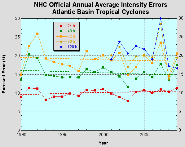
Image Courtesy: National Hurricane Center
With the huge variety of tropical cyclones that can develop in terms of size, intensity, and surrounding environmental conditions, countless many things have to be considered when forecasting their future track and intensity. Size evolution is important because most hurricanes don't remain the same size that they are at formation. Most hurricanes start out fairly small, though some initialize themselves with a huge circulation. Although they generally increase slowly in size during their life cycle, hurricanes can have periods of rapid expansion, particularly during periods of significant weakening. This is because during a weakening phase such as an eyewall replacement cycle, vertical air velocities in the core are reduced and not as focused, allowing the low pressure field to expand outward slightly, and thus increasing the radius of the circulation. The size of a tropical cyclone affects their intensity because they follow the law of conservation of angular momentum, which states that in a closed system, angular momentum remains constant. The angular momentum of a body is given by:

Where I is the moment of inertia, and ω is the angular velocity of the body. The body's moment of inertia can be expressed as follows:
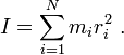
Where mi is a point mass in the body, and ri is the point's perpendicular distance to the body's axis of rotation. Thus, the angular momentum of the body can be written as:
L=mωr^2
Since it is proportional to the square of the radius from the axis of rotation, if the rotating body decreases its average radius, by conservation of angular momentum, its angular velocity must increase. As applied to hurricanes, this is why a hurricane usually intensifies when its eyewall contracts in size. It also explains why it is much harder for a tropical storm to develop from a massive, spread-out area of low pressure, as opposed to a smaller, more concentrated system. All of this presents forecasting challenges to meteorologists trying to predict tropical cyclone formations and intensities.
Overall, although our forecast skill with tropical cyclones is currently limited, and even stalled out in some areas, we are slowly getting better with time, and extensive research is being done to improve our knowledge in this area. The NHC continues to save lives with its hurricane forecasts every season that sees a storm make landfall, providing advanced warnings to residents along the coast.
Predicting hurricanes is one of the more difficult forecast challenges faced by meteorologists today. Tropical cyclones can exhibit some of the more "strange" and erratic behaviors that at this point in time are still rather unpredictable. However, great progress has been made during the last few decades. The National Hurricane Center, responsible for tropical cyclone forecasts in the Atlantic and eastern Pacific basins, has shown considerable decrease over time in its average track forecast errors due to improvements in forecast models and understanding of hurricane dynamics. The NHC was initially only able to make fairly reliable forecasts of hurricanes out to 72 hours, but in 2001 they were deamed accurate enough to extend the official forecast out to 120 hours. The average track errors for tropical storms and hurricanes in the Atlantic basin are shown in the image below:
Image Courtesy: National Hurricane Center
Forecasting the intensity of tropical cyclones, however, has been an issue of greater difficulty and struggle for the NHC, and has shown essentially no improvement over time. This is where we still fall short in our understanding of hurricane dynamics and what keeps them going. Things like eyewall replacement cycles and rapid intensification periods are still fairly unpredictable by the NHC.
Image Courtesy: National Hurricane Center
With the huge variety of tropical cyclones that can develop in terms of size, intensity, and surrounding environmental conditions, countless many things have to be considered when forecasting their future track and intensity. Size evolution is important because most hurricanes don't remain the same size that they are at formation. Most hurricanes start out fairly small, though some initialize themselves with a huge circulation. Although they generally increase slowly in size during their life cycle, hurricanes can have periods of rapid expansion, particularly during periods of significant weakening. This is because during a weakening phase such as an eyewall replacement cycle, vertical air velocities in the core are reduced and not as focused, allowing the low pressure field to expand outward slightly, and thus increasing the radius of the circulation. The size of a tropical cyclone affects their intensity because they follow the law of conservation of angular momentum, which states that in a closed system, angular momentum remains constant. The angular momentum of a body is given by:
Where I is the moment of inertia, and ω is the angular velocity of the body. The body's moment of inertia can be expressed as follows:
Where mi is a point mass in the body, and ri is the point's perpendicular distance to the body's axis of rotation. Thus, the angular momentum of the body can be written as:
L=mωr^2
Since it is proportional to the square of the radius from the axis of rotation, if the rotating body decreases its average radius, by conservation of angular momentum, its angular velocity must increase. As applied to hurricanes, this is why a hurricane usually intensifies when its eyewall contracts in size. It also explains why it is much harder for a tropical storm to develop from a massive, spread-out area of low pressure, as opposed to a smaller, more concentrated system. All of this presents forecasting challenges to meteorologists trying to predict tropical cyclone formations and intensities.
Overall, although our forecast skill with tropical cyclones is currently limited, and even stalled out in some areas, we are slowly getting better with time, and extensive research is being done to improve our knowledge in this area. The NHC continues to save lives with its hurricane forecasts every season that sees a storm make landfall, providing advanced warnings to residents along the coast.