Precipitation
Precipitation refers to any form of water that falls from a cloud to the earth's surface. Rain, snow, and hail are the most common, but there are other types of precipitation such as sleet and freezing rain as well. When moist air is lifted to the point of condensation, forms clouds, and then continues to get lifted upwards, water vapor continues to get "squeezed" out of the atmosphere and condense onto condensation nuclei and other cloud droplets. If the vapor pressure (the pressure exerted by water vapor molecules) of the air remains greater than that of a cloud droplet, it will continue to grow in size. However, this process of condensation is very slow, far too slow to produce a raindrop that can fall to the earth. Although there is much about how rain is produced that is not yet fully understood, there are a couple important processes that are known.
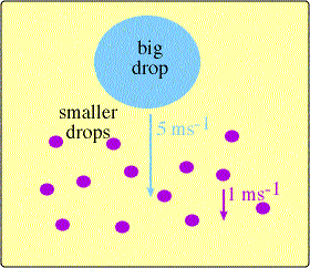 One process that contributes
greatly to the production of precipitation is "collision and
coalescence." As cloud droplets are continuously formed, some will be
larger than others due to large condensation nuclei such as salt
particles, or through random collision and merging of droplets that
results in larger droplets, which is called "coalescence." As the
droplets grow bigger and start to fall, the largest droplets will fall
faster than the others due to their smaller surface-area-to-weight
ratio, and will run into smaller droplets on their way down. Some of
these droplets will merge together Image courtesy: Lyndon
State
College
One process that contributes
greatly to the production of precipitation is "collision and
coalescence." As cloud droplets are continuously formed, some will be
larger than others due to large condensation nuclei such as salt
particles, or through random collision and merging of droplets that
results in larger droplets, which is called "coalescence." As the
droplets grow bigger and start to fall, the largest droplets will fall
faster than the others due to their smaller surface-area-to-weight
ratio, and will run into smaller droplets on their way down. Some of
these droplets will merge together Image courtesy: Lyndon
State
College
to produce ever-bigger water drops, which will eventually make it out of the cloud and fall to the ground as rain. Not all cloud droplet collisions will result in coalescence, as the strong surface tension of small droplets can resist merging and even cause larger drops to break apart during a collision, but there are still enough large water droplets to produce precipitation in clouds with sufficient vertical growth.
Snow:
 Snow
is produced when liquid cloud droplets in a cloud are lifted above the
freezing level and begin to form ice crystals. As it turns out though,
even in a cold cloud or the region of a cloud that is below freezing,
the cloud is still composed mostly of liquid water droplets. In fact,
liquid water droplets still outnumber ice crystals to temperatures as
cold as -20C. The reason for this is that tiny amounts of water
actually resist freezing at the temperature that water normally freezes
at, due to thermal agitations that tend to break up ice embryos
as Image courtesy: COMET Program: MetEd
Snow
is produced when liquid cloud droplets in a cloud are lifted above the
freezing level and begin to form ice crystals. As it turns out though,
even in a cold cloud or the region of a cloud that is below freezing,
the cloud is still composed mostly of liquid water droplets. In fact,
liquid water droplets still outnumber ice crystals to temperatures as
cold as -20C. The reason for this is that tiny amounts of water
actually resist freezing at the temperature that water normally freezes
at, due to thermal agitations that tend to break up ice embryos
as Image courtesy: COMET Program: MetEd
they are trying to form, even in very
cold temperatures. These droplets that remain liquid below the freezing point are said to be "supercooled" water droplets. It must be colder than -40C for almost all cloud droplets to freeze spontaneously, and thus it is only clouds this cold or colder that are comprised entirely of ice crystals.
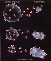 However, few snow-producing clouds actually extend up into
regions colder than -40C, so how can snow form in an environment that
is still mostly liquid? The answer lies in the fact that it is harder
for water molecules to break away from ice than from liquid water, and
thus a higher vapor pressure must exist around liquid cloud droplets to
maintain their equilibrium with the environment. In a cloud where both
liquid droplets and ice crystals are present, the difference in vapor
pressures causes a sort of diffusion of water molecules from the liquid
droplets towards the ice crystals, causing the ice crystals to grow.
The liquid droplets then shrink, and provide a large source of water
for the ice crystals to constantly draw on, allowing them to grow
rapidly. Once the ice crystals grow large enough to succumb to gravity
and overcome any Image courtesy: CBS-WSHM
updrafts in the cloud,
they will begin to fall.
As
they fall they will collide with supercooled water droplets in the
cloud that will freeze on contact with the ice crystals, forming an icy
matter called graupel. This process is called accretion, or riming. As
the crystals continue to fall through the sub-freezing layer, they may
fractures into tiny ice particles that freeze hundreds of supercooled
droplets, which in turn create more graupel and more ice particles,
forming a chain reaction. As the ice crystals continue to fall they
also encounter other ice crystals, some of which will stick to each
other in chains, forming the shapes that we call snow flakes. Through
this process, called aggregation, snow flakes will form and clump
together, creating the white, fluffy masses that float down to us from
the sky during a snowstorm. If snowflakes fall into a warm surface
layer that is above the freezing mark, they will begin to melt and
eventually fall as raindrops if the warm layer is deep enough. It turns
out that the ideal situation for maximum snowflake production occurs
when the ratio of ice crystals to supercooled droplets is on the order
of 1 to 100,000, and when the temperature of the air is near freezing.
However, few snow-producing clouds actually extend up into
regions colder than -40C, so how can snow form in an environment that
is still mostly liquid? The answer lies in the fact that it is harder
for water molecules to break away from ice than from liquid water, and
thus a higher vapor pressure must exist around liquid cloud droplets to
maintain their equilibrium with the environment. In a cloud where both
liquid droplets and ice crystals are present, the difference in vapor
pressures causes a sort of diffusion of water molecules from the liquid
droplets towards the ice crystals, causing the ice crystals to grow.
The liquid droplets then shrink, and provide a large source of water
for the ice crystals to constantly draw on, allowing them to grow
rapidly. Once the ice crystals grow large enough to succumb to gravity
and overcome any Image courtesy: CBS-WSHM
updrafts in the cloud,
they will begin to fall.
As
they fall they will collide with supercooled water droplets in the
cloud that will freeze on contact with the ice crystals, forming an icy
matter called graupel. This process is called accretion, or riming. As
the crystals continue to fall through the sub-freezing layer, they may
fractures into tiny ice particles that freeze hundreds of supercooled
droplets, which in turn create more graupel and more ice particles,
forming a chain reaction. As the ice crystals continue to fall they
also encounter other ice crystals, some of which will stick to each
other in chains, forming the shapes that we call snow flakes. Through
this process, called aggregation, snow flakes will form and clump
together, creating the white, fluffy masses that float down to us from
the sky during a snowstorm. If snowflakes fall into a warm surface
layer that is above the freezing mark, they will begin to melt and
eventually fall as raindrops if the warm layer is deep enough. It turns
out that the ideal situation for maximum snowflake production occurs
when the ratio of ice crystals to supercooled droplets is on the order
of 1 to 100,000, and when the temperature of the air is near freezing.
Hail:
Hailstones are solid pieces of ice that range from the size of small peas to that of baseballs or larger. They form in cumulonimbus clouds (thunderstorms) when graupel or any other ice particles are suspended in the cloud by strong convective updrafts and are allowed to accrete many supercooled water droplets. It takes about a million cloud droplets to produce a typical raindrop, but over 10 billion to produce a golfball-sized hailstone. Thus, an ice embryo must remain suspended in a cloud for a very long time to attain a stone this size, usually between 5 and 10 minutes. As the ice embryo grows and slowly descends, violent updrafts can recapture it and whisk it upwards to high heights in the cloud over and over again. As the hailstone passes through the region of supercooled water droplets successive times, it accumulates a new layer of ice coating each time, which gives it a layered structure as it grows. In especially strong thunderstorms, updrafts can suspend hailstones in the cloud for very long periods of time, resulting in stones of extraordinary size. The largest hailstone on record fell on Vivian, South Dakota on July 23rd, 2010. It weighed 880 grams (1.93 pounds), with a diameter of 8 inches. Hailstones larger than golf balls can cause extensive damage to houses, cars, crops, and other property, as well as being a danger to people outside.
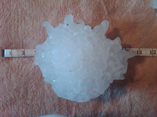
Photo Courtesy: National Weather Service, Central Region Headquarters
Sleet and Freezing Rain:
When snowflakes fall into an air mass that is warmer than freezing, they begin to melt.
If an inversion layer exists, where above-freezing air temperatures exist in a layer above a subfreezing surface layer, the partially-melted snowflakes or raindrops will turn back into ice as they fall into the subfreezing layer, but instead of being snowflakes again, they will turn into small ice pellets called "sleet." These pellets generally have a diameter of 5mm or less, and bounce when they hit the ground or hard objects, making sounds similar to small hail.
Freezing rain occurs when raindrops that pass through a subfreezing layer at the surface that is too shallow to freeze them reach the ground as supercooled liquid drops. They will freeze nearly instantaneously upon striking a cold object or surface after they spread out, forming a glaze of ice. Freezing rain can be very dangerous to travelers, as it can coat roads and walkways with unforgivingly slick ice. In extreme cases, large accumulations of ice can weigh down power lines and trees until they fall, and ruin crops in areas that grow year-round. If more than 0.25 inches of ice accumulates from freezing rain, the National Weather Service designates the event an "ice storm."
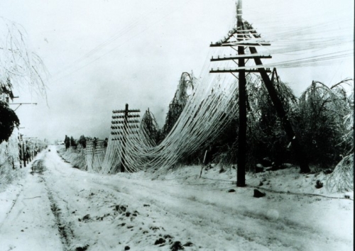
Ice accumulation from an ice storm weighs down power lines and trees.
Photo courtesy: NOAA Photo Library
Precipitation refers to any form of water that falls from a cloud to the earth's surface. Rain, snow, and hail are the most common, but there are other types of precipitation such as sleet and freezing rain as well. When moist air is lifted to the point of condensation, forms clouds, and then continues to get lifted upwards, water vapor continues to get "squeezed" out of the atmosphere and condense onto condensation nuclei and other cloud droplets. If the vapor pressure (the pressure exerted by water vapor molecules) of the air remains greater than that of a cloud droplet, it will continue to grow in size. However, this process of condensation is very slow, far too slow to produce a raindrop that can fall to the earth. Although there is much about how rain is produced that is not yet fully understood, there are a couple important processes that are known.
One process that contributes
greatly to the production of precipitation is "collision and
coalescence." As cloud droplets are continuously formed, some will be
larger than others due to large condensation nuclei such as salt
particles, or through random collision and merging of droplets that
results in larger droplets, which is called "coalescence." As the
droplets grow bigger and start to fall, the largest droplets will fall
faster than the others due to their smaller surface-area-to-weight
ratio, and will run into smaller droplets on their way down. Some of
these droplets will merge together Image courtesy: Lyndon
State
College
to produce ever-bigger water drops, which will eventually make it out of the cloud and fall to the ground as rain. Not all cloud droplet collisions will result in coalescence, as the strong surface tension of small droplets can resist merging and even cause larger drops to break apart during a collision, but there are still enough large water droplets to produce precipitation in clouds with sufficient vertical growth.
Snow:
Snow
is produced when liquid cloud droplets in a cloud are lifted above the
freezing level and begin to form ice crystals. As it turns out though,
even in a cold cloud or the region of a cloud that is below freezing,
the cloud is still composed mostly of liquid water droplets. In fact,
liquid water droplets still outnumber ice crystals to temperatures as
cold as -20C. The reason for this is that tiny amounts of water
actually resist freezing at the temperature that water normally freezes
at, due to thermal agitations that tend to break up ice embryos
as Image courtesy: COMET Program: MetEd
they are trying to form, even in very
cold temperatures. These droplets that remain liquid below the freezing point are said to be "supercooled" water droplets. It must be colder than -40C for almost all cloud droplets to freeze spontaneously, and thus it is only clouds this cold or colder that are comprised entirely of ice crystals.
However, few snow-producing clouds actually extend up into
regions colder than -40C, so how can snow form in an environment that
is still mostly liquid? The answer lies in the fact that it is harder
for water molecules to break away from ice than from liquid water, and
thus a higher vapor pressure must exist around liquid cloud droplets to
maintain their equilibrium with the environment. In a cloud where both
liquid droplets and ice crystals are present, the difference in vapor
pressures causes a sort of diffusion of water molecules from the liquid
droplets towards the ice crystals, causing the ice crystals to grow.
The liquid droplets then shrink, and provide a large source of water
for the ice crystals to constantly draw on, allowing them to grow
rapidly. Once the ice crystals grow large enough to succumb to gravity
and overcome any Image courtesy: CBS-WSHM
updrafts in the cloud,
they will begin to fall.
As
they fall they will collide with supercooled water droplets in the
cloud that will freeze on contact with the ice crystals, forming an icy
matter called graupel. This process is called accretion, or riming. As
the crystals continue to fall through the sub-freezing layer, they may
fractures into tiny ice particles that freeze hundreds of supercooled
droplets, which in turn create more graupel and more ice particles,
forming a chain reaction. As the ice crystals continue to fall they
also encounter other ice crystals, some of which will stick to each
other in chains, forming the shapes that we call snow flakes. Through
this process, called aggregation, snow flakes will form and clump
together, creating the white, fluffy masses that float down to us from
the sky during a snowstorm. If snowflakes fall into a warm surface
layer that is above the freezing mark, they will begin to melt and
eventually fall as raindrops if the warm layer is deep enough. It turns
out that the ideal situation for maximum snowflake production occurs
when the ratio of ice crystals to supercooled droplets is on the order
of 1 to 100,000, and when the temperature of the air is near freezing.Hail:
Hailstones are solid pieces of ice that range from the size of small peas to that of baseballs or larger. They form in cumulonimbus clouds (thunderstorms) when graupel or any other ice particles are suspended in the cloud by strong convective updrafts and are allowed to accrete many supercooled water droplets. It takes about a million cloud droplets to produce a typical raindrop, but over 10 billion to produce a golfball-sized hailstone. Thus, an ice embryo must remain suspended in a cloud for a very long time to attain a stone this size, usually between 5 and 10 minutes. As the ice embryo grows and slowly descends, violent updrafts can recapture it and whisk it upwards to high heights in the cloud over and over again. As the hailstone passes through the region of supercooled water droplets successive times, it accumulates a new layer of ice coating each time, which gives it a layered structure as it grows. In especially strong thunderstorms, updrafts can suspend hailstones in the cloud for very long periods of time, resulting in stones of extraordinary size. The largest hailstone on record fell on Vivian, South Dakota on July 23rd, 2010. It weighed 880 grams (1.93 pounds), with a diameter of 8 inches. Hailstones larger than golf balls can cause extensive damage to houses, cars, crops, and other property, as well as being a danger to people outside.
Photo Courtesy: National Weather Service, Central Region Headquarters
Sleet and Freezing Rain:
When snowflakes fall into an air mass that is warmer than freezing, they begin to melt.
If an inversion layer exists, where above-freezing air temperatures exist in a layer above a subfreezing surface layer, the partially-melted snowflakes or raindrops will turn back into ice as they fall into the subfreezing layer, but instead of being snowflakes again, they will turn into small ice pellets called "sleet." These pellets generally have a diameter of 5mm or less, and bounce when they hit the ground or hard objects, making sounds similar to small hail.
Freezing rain occurs when raindrops that pass through a subfreezing layer at the surface that is too shallow to freeze them reach the ground as supercooled liquid drops. They will freeze nearly instantaneously upon striking a cold object or surface after they spread out, forming a glaze of ice. Freezing rain can be very dangerous to travelers, as it can coat roads and walkways with unforgivingly slick ice. In extreme cases, large accumulations of ice can weigh down power lines and trees until they fall, and ruin crops in areas that grow year-round. If more than 0.25 inches of ice accumulates from freezing rain, the National Weather Service designates the event an "ice storm."
Ice accumulation from an ice storm weighs down power lines and trees.
Photo courtesy: NOAA Photo Library