Cloud
Formation and Development
What exactly are clouds? A common answer from many lay people is that clouds made up of concentrations of water vapor floating in the air. Although this answer is understandable from an intuitive standpoint, it is wrong. Clouds are actually made up of liquid water, in the form of tiny droplets that are so light that they are able to remain airborne without being overcome by gravity. This makes sense because water vapor is always present in the air, but it is invisible. Clouds, on the other hand, are very visible, as is the liquid water of which they are comprised.
Clouds form from water vapor molecules in the atmosphere that condense into liquid droplets. These droplets are extremely tiny, with a radius on the order of about 10 micrometers. Water is constantly evaporating and condensing into and out of the air when the relative humidity (the amount of moisture in the atmosphere relative to its capacity to hold water vapor) is less than 100%. However, to get a big enough concentration of water droplets in the air that eventually forms a cloud that is visible to the naked eye requires a relative humidity of near 100%. This generally occurs when the air is relatively cool, because the amount of water vapor that the atmosphere can "hold" is proportional to the air temperature. The warmer the air is, the more water the atmosphere can hold in vapor form, because there is more energy available. When the relative humidity is 100%, the air is said to be "saturated" with as much moisture as it can hold, and therefore water vapor can only condense back into liquid. This greatly increases the number of water droplets floating in the air, and this is what creates clouds. However, just having the humidity at 100% is not enough. Tiny airborne particles called "condensation nuclei" are necessary for water vapor to condense onto. Although the air may look clean on an ordinary day, as many as 150,000 particles can exist in a volume of air approximately the size of your index finger. These particles are extremely small and light, with many having a mass less than one-trillionth of a gram. Without them, relative humidities of several hundred percent would be required for water vapor to condense.
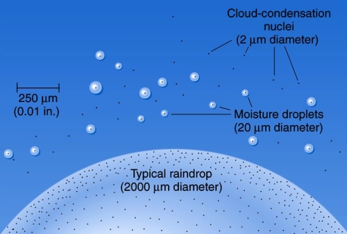
Image courtesy: University of Idaho
Most of the time, the relative humidity is less than 100% at the earth's surface, and thus most clouds float above ground-level. When the relative humidity of the air at the surface of the earth is 100%, a cloud forms in contact with the ground that we call "fog." Often the atmosphere is fairly dry near the surface but becomes saturated at a certain height. This level is called the "condensation level," and represents the height at which water vapor will be forced to condense , and thus indicates where the base of any clouds will be.
Getting water vapor in the atmosphere to condense into clouds is often accomplished by lifting air upwards. The two main processes that cause air to rise are "convection" and forced ascent, usually in the form of weather fronts. Convection is a vertical circulation of air that occurs when air gets heated from below by the ground or ocean water that has been heated by the sun. Parcels of air that are warmer than the air around them will tend to expand and become less dense, and therefore lighter, than the surrounding air and begin to rise. As they rise, the energy lost by the air molecules through the effort of expanding their parcels causes the air to cool. Eventually, as the air continues to rise (as long as it is warmer than the surrounding environment), it will cool to the point at which the relative humidity becomes 100%. This is called the "dewpoint temperature," and occurs at the condensation level. This is where the water vapor contained within the air starts to condense into clouds. The phase change of water from vapor to liquid during lifting also releases a huge amount of latent heat into the atmosphere, adding to the convective instability and causing more air to rise, which in turn condenses more water and releases more heat. This feedback loop is part of what helps clouds grow, especially convective ones. The amount of energy released inside a cloud in this manner is massive. A typical thunderstorm complex can release more energy during its lifespan than a small nuclear explosion. The other way by which air rises is when it is forced upward, usually by weather fronts. An example is a "warm front," when a warm air mass is advancing towards a colder one. At the boundary between the two, warm, less dense air is forced to lift upwards and glide over the top of the colder air mass. The forced lifting cools the air to its dewpoint and causes clouds to form. Both of these situations in which air cools and becomes saturated when it rises are examples of what is called "adiabatic cooling."
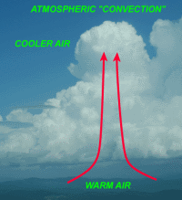

Images courtesy of Lyndon State College and NASA Remote Sensing Tutorial
The different processes that form clouds also give them different appearances. Clouds formed from convection have a great deal of vertical development due to vigorously rising air and have a puffy, billowing look to them. These are called cumulus clouds, and are the most well-known type of cloud. More gradual lifting caused by warm fronts, on the other hand, causes clouds that are layered and flat in nature, with little vertical depth. This family of cloud types is called "stratus," which literally means "layered." At great heights above the earth's surface where temperatures are well below freezing, clouds can be composed entirely of ice crystals. These clouds typically have a wispy, feathery look, and are called "cirrus." A common term used to describe classic wisps of cirrus against a blue sky is "horse tails." Many different cloud types exist as a combination of these three main classifications at the low, mid, and high levels of the troposphere.
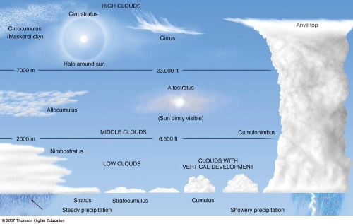
Image courtesy: Lyndon State College
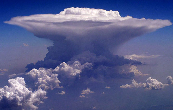
A large cumulonimbus cloud. Photo courtesy: New York University
What exactly are clouds? A common answer from many lay people is that clouds made up of concentrations of water vapor floating in the air. Although this answer is understandable from an intuitive standpoint, it is wrong. Clouds are actually made up of liquid water, in the form of tiny droplets that are so light that they are able to remain airborne without being overcome by gravity. This makes sense because water vapor is always present in the air, but it is invisible. Clouds, on the other hand, are very visible, as is the liquid water of which they are comprised.
Clouds form from water vapor molecules in the atmosphere that condense into liquid droplets. These droplets are extremely tiny, with a radius on the order of about 10 micrometers. Water is constantly evaporating and condensing into and out of the air when the relative humidity (the amount of moisture in the atmosphere relative to its capacity to hold water vapor) is less than 100%. However, to get a big enough concentration of water droplets in the air that eventually forms a cloud that is visible to the naked eye requires a relative humidity of near 100%. This generally occurs when the air is relatively cool, because the amount of water vapor that the atmosphere can "hold" is proportional to the air temperature. The warmer the air is, the more water the atmosphere can hold in vapor form, because there is more energy available. When the relative humidity is 100%, the air is said to be "saturated" with as much moisture as it can hold, and therefore water vapor can only condense back into liquid. This greatly increases the number of water droplets floating in the air, and this is what creates clouds. However, just having the humidity at 100% is not enough. Tiny airborne particles called "condensation nuclei" are necessary for water vapor to condense onto. Although the air may look clean on an ordinary day, as many as 150,000 particles can exist in a volume of air approximately the size of your index finger. These particles are extremely small and light, with many having a mass less than one-trillionth of a gram. Without them, relative humidities of several hundred percent would be required for water vapor to condense.

Image courtesy: University of Idaho
Most of the time, the relative humidity is less than 100% at the earth's surface, and thus most clouds float above ground-level. When the relative humidity of the air at the surface of the earth is 100%, a cloud forms in contact with the ground that we call "fog." Often the atmosphere is fairly dry near the surface but becomes saturated at a certain height. This level is called the "condensation level," and represents the height at which water vapor will be forced to condense , and thus indicates where the base of any clouds will be.
Getting water vapor in the atmosphere to condense into clouds is often accomplished by lifting air upwards. The two main processes that cause air to rise are "convection" and forced ascent, usually in the form of weather fronts. Convection is a vertical circulation of air that occurs when air gets heated from below by the ground or ocean water that has been heated by the sun. Parcels of air that are warmer than the air around them will tend to expand and become less dense, and therefore lighter, than the surrounding air and begin to rise. As they rise, the energy lost by the air molecules through the effort of expanding their parcels causes the air to cool. Eventually, as the air continues to rise (as long as it is warmer than the surrounding environment), it will cool to the point at which the relative humidity becomes 100%. This is called the "dewpoint temperature," and occurs at the condensation level. This is where the water vapor contained within the air starts to condense into clouds. The phase change of water from vapor to liquid during lifting also releases a huge amount of latent heat into the atmosphere, adding to the convective instability and causing more air to rise, which in turn condenses more water and releases more heat. This feedback loop is part of what helps clouds grow, especially convective ones. The amount of energy released inside a cloud in this manner is massive. A typical thunderstorm complex can release more energy during its lifespan than a small nuclear explosion. The other way by which air rises is when it is forced upward, usually by weather fronts. An example is a "warm front," when a warm air mass is advancing towards a colder one. At the boundary between the two, warm, less dense air is forced to lift upwards and glide over the top of the colder air mass. The forced lifting cools the air to its dewpoint and causes clouds to form. Both of these situations in which air cools and becomes saturated when it rises are examples of what is called "adiabatic cooling."


Images courtesy of Lyndon State College and NASA Remote Sensing Tutorial
The different processes that form clouds also give them different appearances. Clouds formed from convection have a great deal of vertical development due to vigorously rising air and have a puffy, billowing look to them. These are called cumulus clouds, and are the most well-known type of cloud. More gradual lifting caused by warm fronts, on the other hand, causes clouds that are layered and flat in nature, with little vertical depth. This family of cloud types is called "stratus," which literally means "layered." At great heights above the earth's surface where temperatures are well below freezing, clouds can be composed entirely of ice crystals. These clouds typically have a wispy, feathery look, and are called "cirrus." A common term used to describe classic wisps of cirrus against a blue sky is "horse tails." Many different cloud types exist as a combination of these three main classifications at the low, mid, and high levels of the troposphere.

Image courtesy: Lyndon State College

A large cumulonimbus cloud. Photo courtesy: New York University