Seismic
equipment and field operation
Twelve
seismic refraction lines were used in
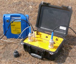
RAS-24
Seismograph from seistronix.com
n
Available with 12 or 24 channels
n
24-Bit Delta-Sigma A/D conversion
n
Wide dynamic range (117db @ 2ms)
n
Connect up to 5 boxes (120 channels)
n
3D on up to 5 lines
n
Automated system performance tests
n
Signal enhancement for noise reduction
n
Operates with any laptop
n
Lightweight - 10 lb
n
Uses standard 12-channel spread cables
Receivers were geophones set at 5.0 m spacing.
The energy source was a 30 pound hammer beaten against an aluminum plate.
Twelve holes were dig along a straight path with an extent of 55.0 m. Organics
were removed from the surface to allow the geophones to receive correct
signals. Bad weather and external vibrations may have contributed to incorrect
data collection.
According to the US Army
exploration Geophysics book, the method of seismic refraction allow us to
record the time of the first arrival of the vibration wave to the geophone
after a shot with the hammer. Ray paths go downward to the boundary and are
refracted along the boundary and return to the surface to impact the geophones.
The data collected during the survey was not the best quality. The holes
where the geophones and the aluminum plate were located got wet. The equipment
got also wet so at the time the group was collecting the data the reading
received by the geophones were not accurate. Two attempts to collect data from
the last 6 channels were made to try to get better data. The presence of external noise made by
several trucks passing the road close to the site made accurate data collection
more difficult. The seismic data was processed by using computer software such
as Ras-24, Rayfract and surfer.