Exploring the Geomagnetic Field
|
Paleomagnetic observations Inner core rotation
Intensity
The hydromagnetic dynamo model Declination |
|
The main field Secular variations
Core mantle coupling
The non-dipole field Isolines |
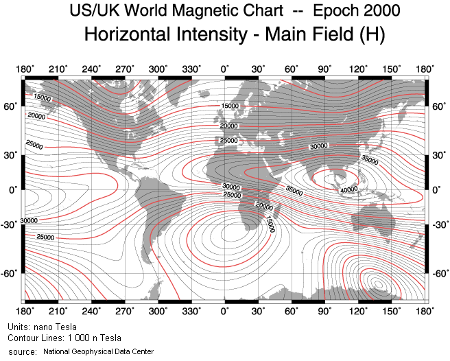 source: http://www.ngdc.noaa.gov/seg/potfld/img/wmm2000h.gif
 |
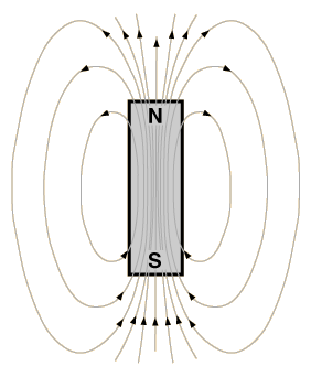
A magnetic field is a concept that can be viewed as an aura with lines of force surrounding a magnet or an electrical conductor. The strength of a magnetic field is measured in Tesla and is determined by the product of the permeability constant for the conducting material and the magnetic flux. Magnetic strength depends on the density of the field lines. The geomagnetic field measures approximately 0.00004 Tesla (Hecht, 2003) and that is rather weak compared to the magnetic force (~0.3 to 0.4 Tesla) of a large ferromagnetic bar (2003). This is why we don’t feel a force, yet some organisms sense the polarity and use it for their migrating habits. This is how birds, whales, or dolphins are thought to navigate. Also insects such as bees show a sensibility, and cell wallS of a magnetotatic bacteria contains tiny magnetic minerals, purportedly for orientation (Hecht, 2003). The magnetic properties of Earth resemble that of a dipole aligned in a south to north direction. The field lines of a bar magnet always point from north to south as does a compass needle; conventionally, the magnetic North Pole is called 'north' because of its geographic location. The real magnetic north pole, however, is currently located south while the North Pole is the magnetic south pole. The force of the geomagnetic field as a vector can be described with directional elements: Inclination, declination, and horizontal and vertical intensity. The picture below equates Earth's dipole to a short bar magnet. It shows how a free-floating magnetized needle would align itself along magnetic field lines at different latitudes. This vector of the field's force is called inclination.
|
Because the magnetic poles are aligned in an angle to Earth's geographic poles, a north-seeking compass needle for that reason never really points to true north; it needs to be adjusted for the declination. Currently, the North Pole is located in the Canadian Arctic at 82.7 degrees N and 113.4 degrees W (National Geophysical Data Center, 2004), and it forms an angle of deviation of about 11.5 degrees (Backus et al., 1996). Declination is measured in degrees east and determines the position relative to the geographic pole. Values are positive when the angle is east of geographic north and negative on the westside. As the location of the poles change --the North Pole moves about 10km northwestward each year (Rodzell, 2003)--declination changes relatively quickly. For more information on the variations to the field click here Other vectors for the field are the horizontal intensity denoted as H with north (X) and east (Y) components, and the vertical intensity (Z).
Total intensity (F) is measured in nanoTesla (nT) and is configured with a simple equation The strength of the main magnetic field is mapped on isomagnetic charts such as the one above showing the distribution for horizontal field intensity. The contour lines representing constant values for horizontality are called isolines. Charts are individually drawn for the other components as well, and also for the total intensity. The lines for the declination and the inclination are termed isogonic and isoclinic respectively, and those for the total intensity chart are called isodynamic. Foci are known as isopores. With over 200 observatory stations around the world and satellite surveys, changes to the field are constantly monitored and charts are updated every five years. The International Geomagnetic Reference Field IGRF is a current model of the magnetic field that is accurate to within 200 nT (National Geophysical Data Center 2004). These models do not account for localized crustal inconsistencies, so for a computation of magnetic field values for your area, to go the National Geophysical Data Center Geomagnetism is a growing science. It has application not just for the resolution to the dynamics of internal Earth, but also for research on a microscale. Here, the magnetic properties of substances are used for environmental studies, archeology, microbiology and sedimentation analysis. |
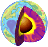
The source: The Geodynamo. Earth's magnetic field is continuously regenerated. Paleomagnetized rocks tell us, it has been doing so for over 3.5 Billion years (Backus et al., 1996). This is thought to be due to a well-working convection mechanism inside Earth in which hot fluid circulation facilitates electric and magnetic fields as Earth rotates. We really do not what Earth is like in the inside, but from its dynamics and vital signs, inferences can be drawn. Scientists are pretty sure it is a high temperature, high pressure realm. See the model for a multiphase layering below. The hot outer core is a viscous layer above the solid inner core and below the semi-rigid mantle and the lithified crust. From the monitoring of seismic activities, scientists could determine that the outer core is liquid and that the inner core is solid and extremely hot. The center of Earth is generally thought to be composed of iron, nickel, titanium, and other heavier elements. For a geodynamo model, according to many writers (Merrill & McElhinney, 1983; Backus et al., 1996; Glatzmaier, 1997 and others), the compositional variability and the temperature gradient is seen as a likely cause of electromagnetism. In the most simplest way, heat exchange between the boundaries is responsible for fluid convection inside the liquid or viscous inner core (indicated as the red, purple and blue convection cells in the picture above) and, like a simple disk dynamo produces a current when a conductor moves through a magnetic field, this circulationg flow of highly conducting material induces electrical currents. The motion of the fluid is thought to be complicated by the differential rotational movement of Earth's layers, by a resistivity at the boundaries and the Coreolis effect, a torque exerted by Earth's rotational movement. The paths of these fluids are therefore likely to be twisted in a helical or vortex-like fashion, crossing the geomagnetic field lines in many ways. The currents and the thus induced magnetic flux interacts with the existing magnetic field dissipating or reinforcing it again and again. This theory is called the hydromagnetic dynamo model and was first introduced in 1955 by E. N. Parker (Merill & McElhinney, 1983). This non-mathematical theory is according to Backus et al. oversimplified, and the pioneering theory has been expanded with additional suggestions for conducting fluid motion inside a magnetic field and physical implications for kinematic reactions or fluid velocities among others. Numerical simulations executed by modern supercomputers currently test the applications for the proposed geophysical mechanisms. For more on the geodynamics go here
|
 source: http://hyperphysics.phy-astr.gsu.edu/hbase/magnetic/magearth.html
 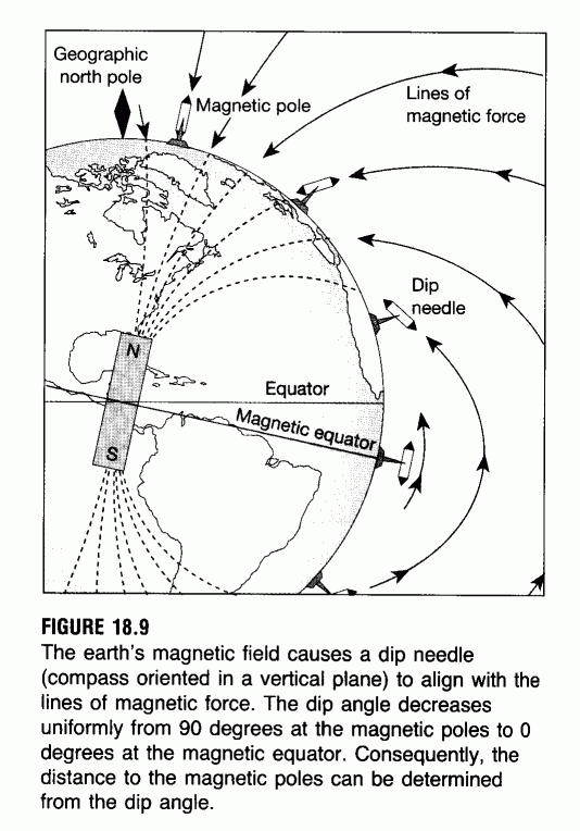 source: http://geophysics.ou.edu/gravmag/mag_earth/mag_earth.html
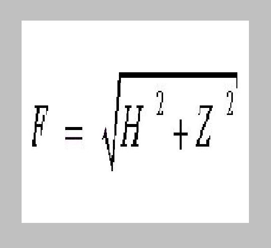
 source: http://www.phy6.org/earthmag/dynamos2.htm